
|
Accessories
Hooks
|
Rods
Reels
|
Lines & Braids
Lures
|
Tools & utilities
Harnesses & Belts
|
Bottom Fishing
Fish Attractor
|
|
Fighting Chair
Triggering clip
Deep Fishing
|
Outriggers
Chandlery
Downriggers
|
GafFs & Bats
Electonics
Fish Chum Dispensers
|
Kites Fishing
Binoculars
|
|
|
Hats
Visors
Caps
|
Gloves
Short
T-Shirt
|
Pants
Sweaters
Jackets
|
Towels
Neck Srap
Glasses
|
|
|

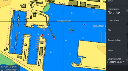
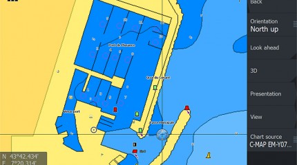
C-MAP MAX-N+ brings trusted C-MAP data and advanced charting features to users of compatible Lowrance, Simrad and B&G navigation systems.


Whether you’re an avid saltwater angler, sailing enthusiast or long-range cruiser, these powerful charts will enhance every moment you spend on the water.
With huge coverage areas, up-to-date data and state-of-the-art features, no adventure is out of reach.
C-MAP MAX-N+ is packed with features that enhance any boating lifestyle.
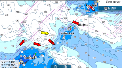
Dynamic Raster Charts give sailors a traditional “nautical chart” view with the ability to access important information. High-Resolution Bathymetric (HRB) charts and Sportfishing Data deliver powerful technology for avid anglers.
Tides & Currents projections help both sailors and anglers plan their day.
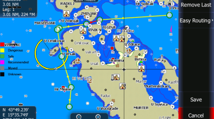
Easy Routing helps to automatically plot the shortest, safest route based on detailed chart data and user vessel information.
New depth shading: many options available whether you set a safety depth, maintain a paper like view or your own custom color for depths
With these features and many more, C-MAP MAX-N+ is ready to take your boating enjoyment to new levels.
C-MAP MAX-N/MAX-N+ provide boaters with the accurate, up-to-date vector chart detail including Depth Areas and Contours, Spot Soundings, NavAids, Light Sectors, Wrecks/Obstructions, Small Craft Facilities and more.

The detail and information available with C-MAP MAX-N/MAX-N+ charts lets boaters approach any harbor and inlet with confidence. The perfect conclusion to a long voyage, sailing adventure or exciting day of bluewater fishing
The C-MAP MAX N+ Tides & Currents feature presents the time, water level and direction of tides with Tide Level graphs and indicates predicted current time, direction and strength of currents with Current Flow graphs and colored arrows. This information is vital for navigation and fishing.
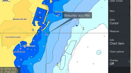
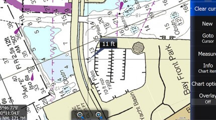
C-Marina Port database and detailed marina charts in C-MAP MAX-N+ provides useful, categorized information for cruisers, fishermen and sailors — including Port Layout and Facilities, Operating Hours, Accessibility, Phone/Email Contact Info and more.
Automatically plots the shortest, safest route based on detailed chart data and vessel information. Easy Routing quickly takes two points and generates a suggested route, while highlighting potential dangers such as shoals, sandbars, submerged rocks and other obstacles.
Docking in an unfamiliar port is no problem, when you have precise layouts of thousands of marinas, including slip spaces, restricted areas, and other valuable navigation information
Traditional “paper chart” look with unique ability to access information on buoys, lights and other details.
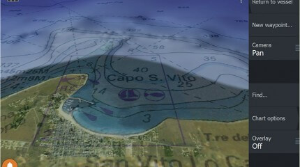
High-resolution satellite imagery provides real-world reference, enhances situational awareness for coastal navigation
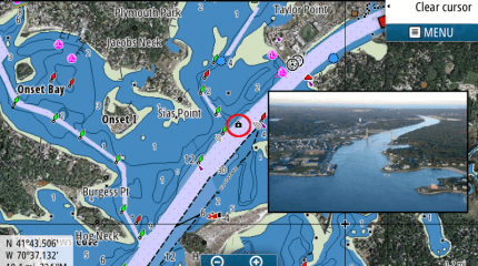
High-Definition Photos & Diagrams of ports, marinas and significant navigational marks

No customer reviews for the moment.
| Product | Model | Stock | Price (tax excl.) | |
|---|---|---|---|---|

|
CENTRAL MEDITERRANEAN | check IN STOCK |
124.92 € |
C-MAP MAX-N+ brings trusted C-MAP data and advanced charting features to users of compatible Lowrance, Simrad and B&G navigation systems.